Technical Assessments
Transport
The main site access for vehicular traffic into the western parcel is proposed as a new three-arm priority junction with A4010 Risborough Road. A 3.0m wide footway will be provided on the northern side of the access and a 2.0m wide footway provided along the southern side, which will connect to the existing footway network on A4010 Risborough Road.
A secondary emergency access into the western parcel is proposed via Hampden Road, which would form a new priority junction with Orchard Close. The access road width proposed is 3.7m with 2.0m wide footways on both sides of the carriageway. The access road and footways will connect with the existing network on Hampden Road and Orchard Close.
Access to the eastern parcel is proposed via a new arm off the A413 Wendover Road/Marroway priority roundabout. A 3.0m wide footway will be provided on the northern side of the access with a 2.0m wide footway along the southern side, which will connect to the existing footway network on A413 Wendover Road.
The existing Public Rights of Way in the site will be retained and upgraded to provide an all-weather shared footway/cycleway, which will significantly improve connectivity between services located on and close to Risborough Road and residents on Wendover Road and Marroway.
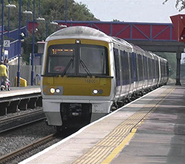
The additional traffic the proposed development is predicted to generate is around 356 to 360 vehicular trips in the AM and PM peak hours. Junction capacity assessments, which consider the cumulative effects of other committed developments and infrastructure in the area, will be undertaken. The results will be reported in a Transport Assessment alongside an assessment of highway safety matters. Bus stops are located on A4010 Risborough Road (approximately 400 metres from the centre of the site) and A413 Wendover Road (approximately 250 metres from the centre of the site). The development includes proposals for a pedestrian/cyclist connection to Stoke Mandeville Railway Station via the existing car park.
A Travel Plan will set out measures to promote and encourage the use of sustainable transport.
Drainage
According to the Environment Agency Flood Map for Planning, the application site is located entirely within Flood Zone 1 (Very Low Probability), which is land defined as having less than a 1 in 1000 annual probability of river or sea flooding.
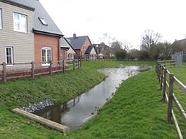
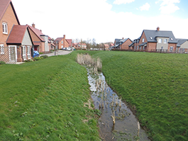
There are a few ditches within the site boundary but they are poorly defined with no apparent outfall. The watercourse along the southern boundary is clearly defined, has significant depth and capacity and will provide an outfall for the entire site.
The EA surface water flood mapping identifies areas of low to high risk of flooding but these are located around the peripheries of the site and away from the areas of proposed residential development. Notably, there is an area of surface water flooding to the north of the eastern parcel which, upon site investigation, has no outfall and risks flooding to nearby properties. The surface water infrastructure provided by the development will remove this flooding and further reduce the flood risk from surface water within the site and the surrounding areas. Flood risks from other sources have also been assessed and pose little to no risk to the development.
An appropriate Surface Water Management Strategy, which complies with the latest local and national advice, will be implemented on the site to attenuate the increase in surface water runoff caused by development. Both parcels will alter the existing catchments as such, to ensure the risk of flooding downstream is not increased, the limiting discharge rates will be based off the existing catchment areas that drain to the watercourse. The rate at which the runoff is discharged will be restricted to the equivalent greenfield runoff rate for events up to the 1 in 100-year event plus an allowance for climate change. This will not only prevent an increase in flows leaving the site but in more severe events provide a substantial reduction, thus ensuring that the proposed development does not have a detrimental impact upon flood risk elsewhere.
The drainage will be designed to provide amenity and biodiversity benefits, as well as water quantity and quality control.
Foul drainage will drain via a combination of pumped and gravity networks which are to be delivered as part of the development. It is proposed to discharge to the existing TW foul sewers close to the site.
Utilities
Eastern Site
Thames Water expect to take a point of connection from the existing 12’’ Cast Iron Water main located within Wendover Road. As part of the works Thames Water will undertake a full modelling study on the wider network to ensure existing supplies are not affected by the development proposals.
UK Power Networks have an existing overhead Electricity Network that runs across the proposed development site, it is currently proposed that this network will be replaced with a new network under ground. This newly diverted network is also expected to provide a connection point to supply the new onsite substations to power the development.
Openreach will provide full fibreoptic telecommunications services to the site, however there are alternative telecommunications providers who can also provide telecommunications services to the proposed development, these can be explored further as the details of the proposed development site progress.
Western Site
Thames Water currently expect to take a point of connection from the existing 12’’ Cast Iron Water main located either from towards Whitethorn Close or back towards Wendover Road. As part of the detailed design works Thames Water will undertake a full modelling study on the wider network to ensure existing supplies are not affected by the development proposals & ultimate connection point.
A 12’’ Water Mains runs through the centre of the proposed development site, this main is proposed to be suitable re-routed through the proposed development site to ensure supplies are maintained.
UK Power Networks have existing overhead Electricity Networks that run across the proposed development site, it is currently proposed that these networks will be replaced with a new network underground.
With regards to new Electricity connections for the proposed development these will be provided at High Voltage, expected to connect at the proposed development site access with Risborough Road. The development site will have its own Transformers/Substations installed to provide low voltage Electricity supplies as required.
Openreach will provide full fibreoptic telecommunications services to the site, however there are alternative telecommunications providers who can also provide telecommunications services to the proposed development, these can be explored further as the details of the proposed development site progress.
Other Assessments
Additional assessment work has been undertaken to inform the proposals for the site including a landscape assessment, ecology surveys, archaeology, and heritage work. The planning application when submitted to the Council will include all relevant reports and information.